
A riddle: how was the iron industry similar to the spongy moth caterpillars that, as I write, are chewing up the leaves of entire mountainsides? Answer: left unchecked, they both tend to eat themselves out of house and home.
For the iron industry, of course, that meant chopping down forests faster than they can regrow, thus choking off the industry’s fuel supply.
Ironically, around the time John Muir was pioneering a path for the American environmental movement, voices within the iron industry were also speaking out for conservation — not for love of nature, but for the sake of self-preservation. Silliman believed that the “entire consumption” of the “very dense forest” of 1820 “would seem beyond the power of any population which is likely ever to accumulate in these regions.” But an 1880 article in the Journal of the US Association of Charcoal Iron Workers stated plainly: “The large area of woodland which is annually cleared to produce fuel for the various charcoal iron works of the country would indicate that but a few years of existence are still granted to the industry.” Also: “We are really the only trade organization whose interest it is to encourage the growth of the forests.” In many areas, there was a concerted attempt to restrain the clear cutting of woodlands, and fight the fires and over-grazing that also threatened forests. Some tried to use more sawmill scrap for charcoal making. But the industry was always up against the vast and non-stop need for more and more wood; the 1880 article estimates that the industry as a whole consumed 1,120, 000 cords per year.
How did this play out in the Taconics? There may have been very few colliers in the area in 1860, but there were plenty of furnaces. In the second half of the 19th century, blasts burned in Copake, Irondale, Maltby (near present day Rudd Pond), Salisbury, Falls Village — and the Mount Riga furnace was only recently shut down. (For the sake of argument, I’m leaving out the many furnaces that were a little further afield). The obvious conclusion is that most of the valuable wood in the Taconics had already been fed to the furnaces, and owners were reaching out for new sources of fuel.
Some math reinforces this idea. How many acres of wood per year did a typical furnace require? Estimates are only loose guesses because, of course, there really was no “typical” furnace: their size and efficiency varied widely. The Copake furnace required 450,000 bushels of charcoal per year; given that an acre produced about 30 cords of wood, and three cords produced 100 bushels of charcoal, then that furnace clear-cut about 450 acres per year. But let’s take the lowest estimate I’ve found and say the furnaces ringing the mountains required about 330 acres of cut woodland per year. The entire South Taconic range encompasses about 36,000 acres. So one furnace in one year would eat up less than one percent of the South Taconic forest. But there were at least five furnaces on the borders of the woodlands. Five furnaces would burn 1,650 acres per year, or close to five percent. A clear way to imagine the impact is to estimate that the entire 36,000 acres, at this rate, would be cleared in about 22 years.
Another way to consider the impact of charcoaling is to ask: how many charcoal pits were in operation in the 19th century? Edgar Masters, owner of about 800 acres close to the site of the Copake Furnace, has diligently counted and found 154 charcoal pits on his land alone. The Hawthorne Valley Farmscape Ecology program has used LIDAR technology (which utilizes aerial imagery to spot sites fitting the shape and size of charcoal pits) to demonstrate that there once were several hundred just along the New York edge of the mountains. Not all of these were in use at the same time, of course, but the sheer numbers speak to a powerful impact on the landscape.

All this speculation immediately invites more speculation. Did those five furnaces exclusively use wood from the Taconics? Doubtful. But, conversely, did some of the other furnaces in the region also draw charcoal from the tri-state mountains?
Forest, of course, didn’t cover all the mountain land to begin with: in 1850, with Mount Washington’s population near its peak, farmers held 2,730 acres of “improved” land, and 5,554 “unimproved” acres. “Unimproved” land meant it was “used for farm purposes other than growing crops.” So something like 7,000 acres of mountain land might have been deforested with no help from colliers.
Also: iron furnaces were not the only hungry industries in the mountains. By 1820, there were sawmills along Bash Bish creek, on the Wright farm, and one near Sky Farm. An 1858 map of Mount Washington shows three sawmills still in operation. A tannery along Huckleberry Brook might have had an outsized impact on the forest: hemlocks didn’t make good charcoal, but were precisely the sort of wood needed for tanning leather.
All these layers of evidence help to clarify the picture I most want to see: what did the mountains look like in, say, 1900? Ernest Rebillard told his children that by the end of his collier days the mountains had been “stripped.” But this may have been an exaggeration. Consider, for one thing, that clear-cuts don’t stay clear-cut; forest immediately begins to regenerate, especially from species that can stump-sprout. Within thirty years or so, a woodlot might contain trees large enough to cut again. Hemlocks, spared the ax by colliers, bear evidence of this pattern. Foresters have examined tree ring patterns that show heftier growth roughly every thirty-five years — suggesting that the hemlocks’ competition had been decimated every three decades or so.
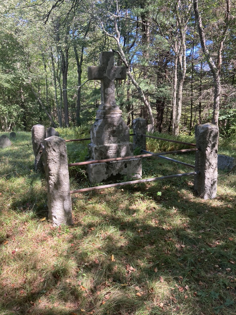
There are several old images that bear this out. For quite a while, I puzzled over a turn of the century painting of the tri-state boundary marker near Mount Frissel. Why did the monument seem to rise in an open field? Oh! I finally realized — the mountainside was a scrubby field at that time. A circa 1890 photograph of the old Dutch cemetery from Picturesque Berkshire shows a vista of open ground and patches of forest. A view from around that time, looking west from Mount Riga, seems to show unbroken forest.


The Book of Berkshire contains several detailed descriptions of the Taconics landscape, circa 1871. This volume seems written with an eye towards growing the young tourist industry of that era, so perhaps its images skew towards the pretty. But while the Reverend Powell rhapsodized over the area’s autumn foliage, he also carefully recorded the tree species of his day: hemlock, sumac, hard and soft maple, oak, beech, sugar maple, birch, and chestnut. “The sidehills,” he tells us, “were masses of gold.” Mrs. Goodale, of Sky Farm in Mount Washington, tells of: “Green fields, cattle on hills, scattered farmhouses, broad stretches of woodland, occasionally laid low by the woodchopper’s ax, plumed by the soft wavering column of the charcoal pit but oftener answering only to rhythmic fingers of the wind and echoing no harsher sounds than the cooing of the wood-dove or the persistent plaint of the whip-poor-whill.” A boarder at Alander House (which stood near where the Massachusetts State Forest Headquarters stands today) saw “From all my windows the grandest and loveliest scenery …. Within a few minutes’ walk over a notch in Ashley Hill I could be in the great lonely wilderness stretching away west and north to Alander Mountain which was fairly palpitating with vivid color.”
It seems clear from such eyewitness accounts that all those swinging axes had failed to erase the forest. Here, a working pasture. There, a field going back to juniper and pines. Over there, acres of stumps. That way, intact forest. This must have been the landscape left by the industrial age.

Each clear-cut would have undergone a predictable succession, similar to patterns seen today. Those adolescent forests of the 19th century, with their pine, birch and aspen, might still seem somewhat familiar to us — with one crucial exception. Because it sprouts so readily from stumps, chestnut would (after the initial cutting) have dominated 19th century woodlands. Some guesses are that 80% of the post clear-cut growth might have been chestnut. But this exceptional tree, renowned for its tasty nuts and straight-grained wood, enjoyed only a short dominion. 1915 saw the arrival of the chestnut blight, which swiftly decimated the species, leaving behind only the stubborn shoots scattered throughout today’s woodlands. Edgar Masters remembers, from his childhood in the 1940s, a forest filled with dead chestnuts which made excellent lumber and firewood. The same forest today is dominated by red oak.

The assault on the forest may have begun to slow not long after the Civil War; the lack of colliers in the 1860 census certainly hints at this. Local forester George Kiefer estimated that most cutting ceased about 1885. An article in the Journal of the United States Association of Charcoal Iron Workers, from that year, states that the Copake furnace was getting most of its wood from Vermont, and the Irondale furnace in Millerton depended on sources “west of the Hudson.” It seems that by then, the local iron industry was on a steady slope towards oblivion. The tone of an 1884 article (in the C.I.W.A. Journal) indicates that the iron district “[o]n the eastern slope of Tocconuc [sic] range of hills” was already seen as a quaint backwater: “Few realize … there are still in existence nineteen charcoal blast furnaces near Salisbury.” (The writer did appreciate the landscape: “The general topographic features are most attractive and nature has generally provided picturesque surroundings for the mines and blast furnaces.”)
Destruction of the forest was not the only reason for this decline. Competition from furnaces in Pennsylvania and the South (where labor was cheaper) cut into profit margins. The high quality local ore became less valuable as new technology allowed furnaces to process lower grade ore. Even more important: a Lakeville man led the way towards new techniques that left the major industry of his hometown obsolete.
Alexander Holley was the great-grandson of Luther Holley, one of the original backers of the Mount Riga furnace. After an early career in the railroad industry, Holley traveled to England in 1862 and met Henry Bessemer, a pioneer in forging steel. He brought this technology home, and by 1880 nationwide production had grown to 1.2 million tons. The rise of steel, sturdier and more resistant, meant the demise of iron.
There were many practical reasons no steel industry took root in the Taconics region, lack of water volume being first. But according to one story, when Holley was asked; “Why not bring steel to your hometown?” the answer was: “Because I love Salisbury so much.” It’s hard for present day residents not to be glad that we were spared more years of industrial flame and noise, of chopping and felling and charring. The decline of the furnaces meant the rise of the forests. Today, it’s hard to imagine the mountains without their verdant covering, but only a few generations separate us from that landscape of stumps and brush and tall trees.
In considering the massive footprint of industry on the Taconics, it’s easy to overlook the places left untouched. There are a few. If you’re wondering why some trees escaped the ax, try hiking along the south side of the Bash Bish gorge—but bring your walking poles! The slope is so precipitous, it’s easy to imagine woodchoppers taking one peek and walking away. Today, that side of the gorge is covered with a dank forest of old growth hemlock.
Or, if you don’t mind thrashing through dense mountain laurel, explore the flanks of Mount Everett or Undine. A 2002 survey estimated there are 350 acres in this area dominated by trees 175-300 years old (a few even older) and another 500-600 acres containing trees 150 years old or more. Again, these forests rise on terrain made remote by steep slopes and narrow ravines.

I used to imagine that “virgin” forests might be found only in the West, or perhaps remote corners of the southern Appalachians, in forgotten pockets containing massive and towering trees. But the old growth in the Taconics is remarkable for its diminutive size. Diameters of 14-28 inches are typical, and one observer describes an “elfin forest of bizarre shapes.” These gnarled hemlocks, red oaks, black birches, red maples and white pines root into scant soil atop highly resistant schist, and must survive winter’s winds and brutal ice storms. They grow, but slowly. Some of the hemlocks here may be 400 years old.
Atop Race, Bear, Undine, Everett, and nearby Hill 1914 (named for a summit monument bearing that number), an even more stunted and odd forest grows. Shrub-sized pitch pines and bear oak live up there essentially because nothing else can. The soil is even thinner, the winter storms worse. The result is rarities: pitch pine is found in the northeast only in coastal Maine, the Shawangunks, and the Taconics. (I’ve also found a few scattered pitch pines atop Cedar Mountain and along the Paradise Lane Trail.) A 2009 study by Harvard Forest argued against the common notion that frequent fires allow the pitch pines to spread here; their presence is instead explained by the severity of the environment. But survive they do: Hill 1914 boasts a 241 year old pitch pine, the oldest ever found in Massachusetts. The average age of these trees was estimated at 111. The Harvard Forest researchers called it an area “worthy of the most stringent conservation measures.”
But here’s another oddity: walk along the west side of Guilder Pond, just below Everett, and you’re strolling through … another old growth forest? Core samples taken here have shown that some of the hemlocks are 250 to 300 years old. This is not a remote and inaccessible spot; why were these trees left to stand? Maybe no-one ever bothered? Maybe the owner refused to allow cutting? It’s easy to pigeonhole our forebears as unable to see anything in a tree but money. But Judge Donald Warner of Salisbury, reminiscing about his mid-nineteenth century boyhood, recorded of his Great Uncle James: “I could not help observing as I tramped through the woods with my uncle the great love amounting almost to reverence he had for the growing and thrifty stands he had watched from his boyhood – a love which would not permit him to apply the axe to any but decaying or fallen trees from the needs of the farm.” (It must be noted, though, that once Uncle James was dead, this forest was felled as part of the estate division.).

If you view the history of the Taconics ecosystem from a 21st century perspective, the 19th looks like an interruption. Before this era, forest-covered mountains held a wilderness full of wildlife; after—forest-covered mountains held a wilderness full of wildlife. Of course, in all sorts of ways it’s not the same ecosystem. Where are the chestnuts? The elk? The wolves? How about the ash trees, which are steadily falling victim to invasive pests? How about the arrival of the wooly adelgid, a mortal threat to those ancient hemlocks?
But the 20th century was kind to the mountains in many ways. Land stripped and eroded by woodchoppers and sheep grew protective coverings of shrubs and trees. Animals driven out by industry returned and many newcomers (such as coyotes) arrived. The human population shrank, and the human impact diminished—at least at the local level. (Global level impacts such as climate change are another story.)
But the mountains are still used by people, just in very different ways. Once a place for work, they’re now a place for relaxation. Once a center of industry, they’re now a place for retreat from the modern world. But the beginnings of the tourist and second home transformation can be found in the midst of that past era of smoke and noise.